


Governments around the world are committing substantial sums to renew ageing roads, railways and transport systems, as well as to build long-term transport links designed to last at least a century. In Europe alone, market intelligence firm GlobalData anticipates that from 2025 to 2029, rail infrastructure will grow at a 4.8% compound annual growth rate (CAGR), as the European Commission focuses on better connecting capitals and major corridors, increasing capacity, reducing congestion, and lowering long-term emissions. Worldwide, the pipeline of investment in road, rail, airports and bridges could exceed €1.6trn, driven by ageing infrastructure, urbanisation and the need to modernise.
At the same time, transportation is a major source of carbon emissions, accounting for 24% of direct CO₂ emissions from fuel combustion—underscoring the urgency to design more sustainable infrastructure solutions.
Yet delivering resilient infrastructure for a net-zero future, and one potentially shaped by more frequent extreme weather events, is complex. Workforce shortages and tight project timelines are stretching traditional civil engineering workflows to their limits.
Digital technologies such as Building Information Modelling (BIM), cloud collaboration platforms and digital twins are becoming central to reshaping how infrastructure is planned, designed, delivered and maintained.
In this conversation, Guillaume Joubert explains how digital delivery solutions are helping infrastructure teams deliver more resilient and sustainable transport networks—and what the next generation of these tools will look like.
Q: Infrastructure spending is rising globally, but so are expectations. What pressures are civil design teams facing today?
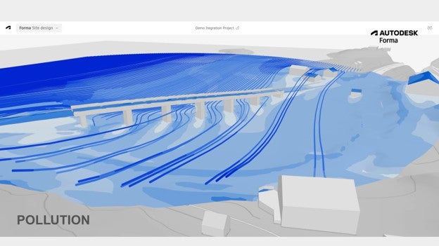
Guillaume Joubert: It’s really all the pressures at once—speed, scope, skills shortage and stakeholder complexity. Demand for infrastructure projects is at its highest in decades. Urbanisation continues to grow, infrastructure in many countries is ageing, and at the same time we must design new projects to withstand climate change. Flooding, heat stress and changing environmental conditions are forcing engineers to rethink how roads and railways are designed.
Take Europe as an example. In parts of western France, regions that historically did not experience severe flooding are now facing repeated extreme events. When designing a road or railway today, you must consider drainage, terrain, water flows and environmental protection from the very beginning. At the same time, the industry is experiencing a significant skills shortage. Fewer students are entering architecture, engineering and construction professions, while experienced professionals are retiring. Teams must deliver more projects with fewer resources.
Digital is a key enabler, alongside process discipline, standards, improved project delivery and skills development.
Q: Where do traditional infrastructure workflows struggle most under these pressures?
GJ: The biggest challenge is fragmentation. Every infrastructure project is essentially a prototype. Unlike manufacturing, where the same product can be built repeatedly, each road, rail line or bridge is unique.
Projects involve many disciplines: geotechnical engineers, transport planners, structural designers, contractors and operators. Traditionally, these teams work with different tools and exchange information manually through documents or email. Data is duplicated, lost or outdated. Studies suggest that 95.5%1 of project data generated during construction is never used again.
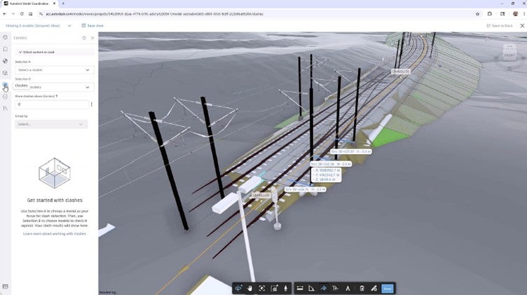
This becomes particularly problematic on large transport projects, where coordination between teams is critical. For example, if the road alignment changes, it may affect drainage systems, lighting infrastructure or utilities placement. Without connected workflows, these dependencies are difficult to track.
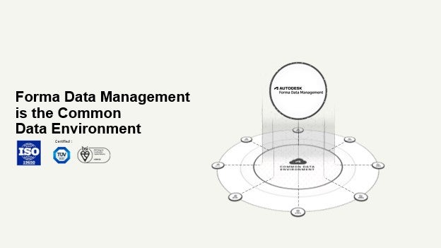
Digital project delivery platforms help address this by creating a shared environment where project information is centralised and accessible.
Q: Owners and operators increasingly expect infrastructure to last decades while remaining cost-effective and easy to maintain. How is that changing what good design means?
GJ: Traditionally, design decisions focused on delivering a project within budget and on time. Today, owners are thinking about the entire lifecycle of an asset, from planning through operations.
This shift is leading to a more outcome-based approach to Building Information Modelling (BIM).
Instead of selecting from a limited number of options early in a project, engineers can now evaluate hundreds or thousands of alternatives digitally. Using advanced modelling and AI-supported analysis, teams can optimise designs for outcomes such as reduced carbon emissions, improved resilience or lower long-term maintenance costs.
For example, when planning a new rail corridor, engineers must consider soil conditions, environmental restrictions, flood risks and construction costs. Digital modelling allows these variables to be analysed simultaneously before construction begins. The result is infrastructure that performs better throughout its lifecycle.
Q: How does digital transformation reshape the full infrastructure lifecycle—from planning through operations?
GJ: At its core, BIM is about building digitally before building in the real world.
During planning and design, BIM enables teams to create detailed 3D models that integrate engineering data, environmental information and project documentation. As the project progresses, the model becomes richer and can evolve into a digital twin, a virtual representation of the physical asset.
A digital twin connects the physical and digital worlds, allowing infrastructure owners to simulate scenarios, monitor performance and optimize operations throughout the asset lifecycle.
For transport infrastructure, this brings significant benefits. Railway operators, for example, can plan construction works more precisely, reducing disruptions to existing lines. Prefabricated components can be designed and assembled digitally before installation, accelerating construction and improving safety.
Data integrity is a major concern on complex infrastructure projects. Where do problems typically arise?
GJ: Most data issues stem from outdated or inconsistent information.
When multiple teams work on the same project, it becomes difficult to know which version of a document or model is current. Engineers often ask: “Do I have the latest data?” or “Has this element been approved?”
This is where standards and structured data management become critical. The global standard ISO 19650 provides guidance for managing information across the lifecycle of built assets. It helps organisations implement version control, approval workflows, naming conventions and a shared source of truth. By combining these standards with common data environments, information becomes more reliable and accessible.
In line with these principles, Autodesk’s platform has been independently assessed and certified by organisations such as TÜV SÜD and BSI2, confirming alignment with ISO 19650 and its information management requirements. Ultimately, most data problems are not technology issues but process issues, so standards provide the necessary structure.
Q: What role does a geographic information system (GIS) – or location intelligence – play alongside BIM in infrastructure projects?
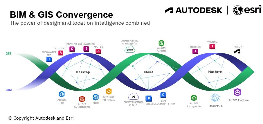
GJ: BIM and GIS strongly complement each other. BIM answers “what” and “how”—how an asset is designed and constructed. GIS answers “where” and “why.”
In transportation projects, GIS provides spatial context, helping planners understand environmental constraints, flood risks, land use and existing networks.
By integrating BIM and GIS, teams combine engineering design with geographic intelligence. This improves decision-making from early planning through operations, while enhancing accuracy, supporting sustainability and ensuring data continuity.
For instance, our partnership with Esri, a global leader in GIS technology, is supporting Italy’s railway modernisation through a BIM/GIS digital twin approach with FS Technology3, the engineering company of Italy’s state railway group. By integrating 3D modelling with geographic context, projects such as the Fortezza–Ponte Gardena and Napoli–Bari high-speed lines benefit from improved planning, better utility management and faster delivery. In some cases, time savings of around 40% have been reported on repetitive tasks.
Q: Are there major projects demonstrating how digital tools are transforming infrastructure delivery?
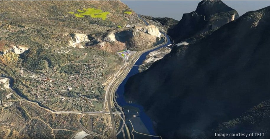
GJ: The Mont-Cenis base tunnel illustrates this well. It is a 57.5km cross-border rail project linking Turin and Lyon, with TELT (Tunnel Euralpin Lyon Turin) as project owner4. Its complexity spans multiple construction sites and a cross-border governance structure between France and Italy.
On this project, digital tools are used not only for design but also to support project delivery. Through BIM workflows and a common data environment, teams improve coordination, integrate data from multiple sources and anticipate construction challenges.
Digital models also support long-term maintenance planning and ensure continuity of information into operations. Projects like this show how digital collaboration helps manage complexity and improve decision-making.
Q: Can you share an example of how AI is already delivering tangible impact in infrastructure projects?
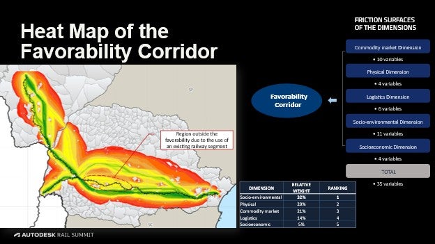
GJ: A strong example is the Nova Ferroeste rail project in southern Brazil5, a 1,300km line connecting one of Brazil’s largest grain-producing regions to the port of Paranaguá.
Here, TPF, an international engineering and consulting firm, used AI capabilities within Autodesk Civil 3D and InfraWorks to identify the optimal route, reducing track modelling time from about a year to four months. The route definition used a multicriteria approach with 35 variables grouped into five dimensions, analysed through the Analytic Hierarchy Process (AHP) combined with artificial intelligence.
The project is expected to reduce transportation costs by 20%, shorten travel times by up to 80%, and lower energy use, emissions and congestion by up to 35%.
Q: What is the next stage of digital transformation for the infrastructure sector?
GJ: The industry has evolved from CAD to BIM and then to Connected BIM powered by the cloud. The next phase is Outcome-based BIM, supported by AI and open data ecosystems.
This approach will allow teams to define clear objectives, whether sustainability targets, cost constraints or resilience goals, and explore multiple design options digitally before construction begins.
To achieve this, the industry must prioritise better information management. Open standards, common data environments and interoperability between platforms will be essential.
The ultimate goal is simple: better infrastructure outcomes. By combining digital technology with engineering expertise, we can build transport networks that are more resilient, sustainable and prepared for future challenges.
[Author]
Guillaume Joubert, Senior Manager, Transportation, Industry and Business Strategy at Autodesk

Guillaume Joubert leads Autodesk’s global transportation strategy and is a structural engineer (MSc) with 25 years of experience in BIM implementation in building and infrastructure. He is co-author of a book on BIM and digital modelling, covering open BIM coordination, structural modelling for stadiums, and formwork and reinforcement design, including the Macau-Hong Kong Zhuhai Bridge project for Bouygues TP. He contributed to virtual design, quantity surveying, and construction planning for VINCI Construction and supported BIM implementation for construction projects involving France’s iconic landmarks, the Eiffel Tower and Notre-Dame.
For a deeper dive into digital project delivery, AI, and sustainable infrastructure strategies, download the full white paper on transforming transportation infrastructure.
Sources:
- FMI_BigDataReport.pdf ↩︎
- https://www.autodesk.com/blogs/construction/driving-digital-standards-autodesk-construction-cloud-achieves-bsi-kitemark-certification-for-iso-19650 ↩︎
- Unlocking efficiency with BIM and GIS in Italian railways, GeoAI to exploit point clouds to inform design, construction & operations ↩︎
- Tunneling rail success in the Alps with digital project delivery ↩︎
- Optimizing the best railway route using AI and multicriteria analysis ↩︎
