Modeling is a vital aspect of architecture, engineering, and construction (AEC) project workflows. However, AEC teams may lack access to essential up-to-date, cohesive datasets, which can lead to a lack of precision in modeling.
The digitalization of AEC processes through cloud technologies and building information modeling (BIM) can greatly assist in more reliable project delivery. In addition, advances in mobile mapping and laser scanning technologies are further enhancing what is possible.
Growing uses of BIM and tech for construction
Despite the legacy mindsets of a reluctance to embrace technology in construction, there are signs that a shift is underway. A GlobalData survey found that the use of BIM is seen as an important tool in achieving efficiency and cost-effectiveness in the construction industry.
BIM allows architects, engineers, and construction professionals to create and optimize designs in a virtual environment. By simulating various scenarios, they can identify potential issues, evaluate energy efficiency measures, and ensure compliance with safety regulations before construction even begins – avoiding costly reworks at a later date.
According to the survey results, significant investment is planned for BIM technology, with 54% of respondents having invested already. Meanwhile, 15% of those surveyed plan to invest within the next two years. Furthermore, 45% of respondents agree that BIM is going to be central to the future of building information.
However, despite the many benefits of technology for modeling, the AEC industry has largely been hesitant to fully embrace further digitalization on a meaningful level.
A 2023 GlobalData survey on BIM usage in the AEC sector found that 65% of respondents reported using it on fewer than 25% of their projects. This is primarily due to the sector’s preference for established practices and traditional workflows, as well as a lack of workers trained to use newer technologies.
Crucially, a BIM model can often be only as much use as the information being fed into it. Therefore, accurate spatial data is essential – and scanning technology has a pivotal role to play.
Transformations in modeling enabled by mobile mapping
Responsibility for creating and updating a BIM model may be outsourced if there is a lack of expertise in-house, but this can present a barrier to accessibility if data is siloed externally and reduces the overall transparency of processes. Outsourcing BIM updates can also make workflows less efficient and lead to a reduction in control over digital environments.
The greater long-term solution is to build BIM expertise within a business, which will require funding for training programs. However, advances in mobile mapping technology now make it possible to gain the necessary spatial data to create and update a BIM model with greater levels of accuracy and quality.
Enhanced scanning devices can provide the most recent spatial data to update the BIM models according to ‘as-built’ or ‘as-is’ conditions onsite. For renovation projects, spatial data of the existing site also provides architects and engineers with an essential foundation for design.
Technologies such as light detection and ranging (LiDAR), and simultaneous localization and mapping (SLAM) help establish a comprehensive picture of the construction site, as well as record detailed measurements of physical structures and objects.
Known as Scan-to-BIM, point cloud data can be used to both create and update BIM models with precise information such as dimensions and quality checks, as well as health and safety regulations. In addition, images from high-resolution cameras can provide a reliable visual reference for point cloud data.
Information is accessible in a centralized platform. Having a single source of truth helps contractors and stakeholders make proactive decisions, rather than being reactive. Teams can work from the same set of information. Architects can ensure their vision is being delivered by the contractors, and modelers can be confident that the data they are working from is consistent with the rest of the project.
Advantages of mobile mapping for modeling
The ability to rapidly capture complete spatial data in eliminates the need for multiple site visits to gain further measurements. These features also provide a precise digital representation of the environment.
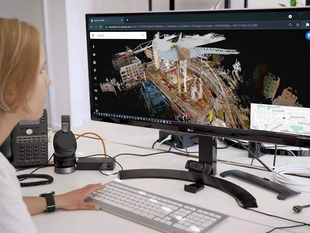
This is where the NavVis reality capture solution can make a significant difference. NavVis VLX is a wearable mobile mapping device that captures complete spatial data and 360° panoramic images of a construction site. Significantly, it is possible to use the device with minimal training.
The NavVis VLX enables users to generate survey-grade point clouds of a site through the SLAM algorithm. A significant advantage of this technology is that it is up to ten times faster than the stationary scanners typically used to produce the data for as-is and as-built BIM models.
Point cloud data and hi-resolution panoramic images are uploaded via the cloud and processed, quickly creating a virtual environment that can be accessed through the NavVis IVION platform on a standard web browser. Users can also navigate the full digital environment virtually.
NavVis technology has been designed to be ‘software agnostic’, using open data formats such as PLY and E57 to support workflows. Furthermore, the NavVis Revit plugin has been developed for compatibility with Revit, which is the industry-standard tool for BIM modeling.
Strengthening modeling capabilities for construction
BIM can be enhanced with as much metadata as required to ensure optimum coverage of a project. Scanned data and images are easy to follow by workers, both on the ground during construction and virtually. In addition, greater accessibility of site data and BIM files results in faster quality assurance and quality control (QA/QC).
Finally, NavVis IVION Core has been designed for surveyors and AEC professionals. The platform enables users to access point clouds in various file formats to allow importing and editing in other programs.
Users can also align scans from third-party devices with NavVis scans. All these factors help to alleviate many of the traditional pain points with modeling for construction and enable processes to be streamlined.
To learn more about how NavVis technology can help your construction project, download the document below.
