The Environment Agency has submitted a planning application to build the £150m Oxford flood alleviation scheme.
This scheme is intended to cut down the risk of the River Thames flooding the city of Oxford.
Go deeper with GlobalData

Discover B2B Marketing That Performs
Combine business intelligence and editorial excellence to reach engaged professionals across 36 leading media platforms.
The Oxford flood alleviation scheme is claimed to be one of the biggest flood schemes currently planned in England.
Oxford has a history of significant flooding, which damages homes and businesses and leads to closure of the railway and major roads into the city.
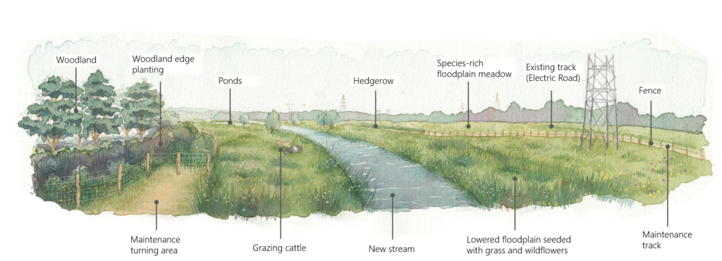
The proposed scheme will see creation of a new stream flowing through a sloping floodplain of meadow with wildflowers and wetland.
The Oxford flood alleviation scheme will lead to the creation of 20ha of new wetland habitat and around 16ha of floodplain meadow.

US Tariffs are shifting - will you react or anticipate?
Don’t let policy changes catch you off guard. Stay proactive with real-time data and expert analysis.
By GlobalDataWhen the water levels in the River Thames are high, the stream will begin to fill the floodplain, thereby minimising the risk of flood in the built-up areas.
The Environment Agency stated that while there would be a minimum of hard engineering, new structures will be created where needed, such as bridges for footpaths to cross the new stream, culverts (tunnels) for floodwater to pass under main roads, and earth embankments and flood walls.
The new stream will be around 5km long, running from just north of Botley Road down to south of the A423 near Kennington, where it rejoins the River Thames.
The planning application has been filed with Oxfordshire County Council, which is one of the partners to the scheme. The other partners in the scheme are Oxford City Council, Vale of White Horse District Council, Thames Water, Thames Regional Flood & Coastal Committee, Oxford Flood Alliance, Oxfordshire Local Enterprise Partnership, University of Oxford and National Highways.
Environment Agency flood risk manager Joanne Emberson Wines said: “The Oxford flood alleviation scheme will reduce flood risk to all properties in Oxford currently at risk of flooding from the River Thames. It’s a long-term solution that will help the city adapt to our changing climate and make it more resilient to future floods.
“The scheme has also been designed to bring environmental and community improvements to the area, creating a new wetland landscape that will benefit wildlife and local people for generations to come. Submitting this planning application is a huge step in making this a reality for communities in and around Oxford.”
————————————————————————————————————–
Image: Artist’s impression of Oxford Flood Scheme, viewed from Devil’s Backbone. Credit: Environment Agency/©Crown