From Alaska to Argentina: The Pan-American Highway’s Epic Journey
“We did it. We – the Vogel family from Boise, Idaho – did it. We did the impossible, and I couldn’t be happier that we did,” wrote Nancy Sathre-Vogel, in her family blog, when she and her family reached Ushuaia, in Argentina.
Alaska to Argentina: Eight years ago, John and Nancy Vogel left their teaching jobs, took their twin boys out of school, bought two single bikes and a tandem and embarked on a journey to cycle the Pan-American Highway.
Go deeper with GlobalData
Discover B2B Marketing That Performs
Combine business intelligence and editorial excellence to reach engaged professionals across 36 leading media platforms.
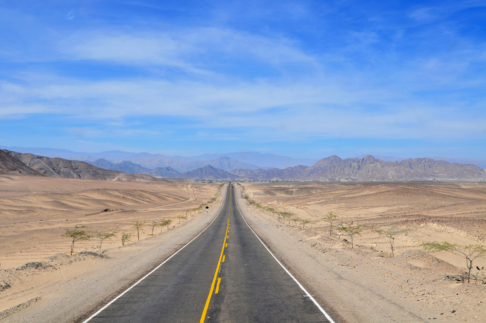
The Pan-American Highway is a network of roads, extending from Prudhoe Bay, Alaska to Ushuaia, Argentina. According to the Guinness World Records, the 48,000km highway, which runs through the North and South American continents, is the world’s longest ‘motorable road’.
The highway comprises official and unofficial sections. The official section runs from Nuevo Laredo, Mexico to Buenos Aires, Argentina, while the unofficial sections can be found to both the north and south of the official route.
The route — including the official and unofficial sections — spreads across 14 countries: the USA, Canada, Mexico, Guatemala, El Salvador, Honduras, Nicaragua, Costa Rica, Panama, Colombia, Ecuador, Peru, Chile and Argentina.
However, if you are thinking in cycling or driving all the way down until Ushuaia without stopping — except to rest, sleep or eat — take that out of your mind.
The route is interrupted by a 160km-wide break, named the Darién Gap, between Central and South America.
The Pan-American Highway is for many the ultimate road trip and here — as part of the WCN’s Roads Week — we provide you with everything you need to know, so you can start, if you fancy the challenge, your ‘little’ adventure.
History
The hypothesis of a route from one point of the Americas to the other — in order to have closer links to its neighbouring countries — was originally proposed by the USA as a railroad at the First Pan-American Conference in 1889. However, nothing was decided at that time.
Alaska to Argentina: The idea resurfaced at the Fifth International Conference of American States in 1923 in Chile, when the Pan-American Highway was envisaged as a single route. Nevertheless, it was not until the sixth conference in Cuba in 1928 that plans were approved.
The First Pan-American Highway Conference was summoned in October 5, 1925, in Buenos Aires with plans presented for a highway starting in Mexico and running south to the Argentine capital.
In 1950, the first portion of the highway was completed in Mexico — the first country to put the proposal into practice, as each country has jurisdiction to designate, maintain or build the section between its borders.
In recent years, the Pan-American Highway Congress — the coordinating body — has begun meeting once every four years.
The highway’s construction greatly benefited from the USA’s financial support, which was crucial to its development — even though the country would not have any official segment of it.
The route very often follows long-established roads or routes, as it is neither one single highway nor a centrally administered road.
From Alaska to Mexico
Prudhoe Bay in Alaska is the starting point of the Pan-American Highway if you are heading north-south. The first 662km follows Dalton Highway to Fairbanks.
The Dalton Highway was built in 1974 as a supply road to support the trans-Alaska pipeline system and was the first road to be included in the BBC’s list of the ‘world’s most dangerous roads’ — at just a few miles from the Arctic Ocean.
From Fairbanks, it follows a 155km link to Delta Junction at the northern end of the Alaska Highway.
The Alaska Highway was built by the US Army Corps of Engineers — as a wartime project — with the motivation of linking Alaska with the USA, through Canada, to help defend against a potential Japanese attack.
The Alaska Highway, shortened since 2012 to 2,232km, ends at Dawson Creek, Canada, from where the route goes on to Edmonton, Alberta, Canada.
Two possible routes are then found. The first, through Minneapolis and following the Interstate 35 through Dallas/Fort Worth, goes into the Mexican border at Laredo, Texas.
The second goes through Calvary, Alberta and Billings, Montana, where it connects with the Interstate 25. Then it passes through Denver, Colorado to Las Cruces, New Mexico and from there on the Interstate 10 to San Antonio, Texas, joining the first route.
Many other routes are possible until Nuevo Laredo in Mexico, since there are no official sections of the highway through Canada and USA.
From Mexico to Colombia
The first official section of the Pan-America Highway starts at the Mexican city of Nuevo Laredo.
From Nuevo Laredo, it goes through the Mexico City along Mexican federal Highway 45 and Mexican Federal Highway 190 on to the border with Guatemala.
The highway continues through Central America: Guatemala, El Salvador, Honduras, Nicaragua, Costa Rica and Panama.
In Costa Rica it has an encounter with the ‘Summit of Death’ — and by the name we can deduce that it will be a challenging section to go through. Here, the highway reaches its highest elevation, at 3,335m.
And if that wasn’t enough, the highway suddenly ends at Yaviza, Panama, where it faces the Darién Gap.
The Darién Gap
The Darién Gap is a large swathe of undeveloped swampland and forest in Panama’s Darién Province in Central America and the north of Colombia’s Choco department in South America.
The gap is 160km long and 50km wide, stretching from the Atlantic to the Pacific.
Over the years, many explorers have been attracted and seduced by the Gap — to do research and explore the area.
In 1510, the Spanish established their first settlement in the Americas there. However, 14 years later it was destroyed by local indigenous tribes.
The Gap continues to be as wild today as it was during the days of the conquest.
Rick Morales, a Panamanian and owner of Jungle Treks, one of the few adventure tour companies in the region, told BBC: “If history had followed its usual course, the Darién should be today one of the most populated regions in the Americas, but it isn’t.
“That’s remarkable if you consider that we live in the 21st Century, in a country that embraces technology and is notorious for connecting oceans, cultures, and world commerce.”
Attempts and efforts to solve this missing link have been made for decades.
Environmental concerns, however, have been significant to stop any effort in that direction.
In 1971, planning to construct a road link through the area started with the help of USA funding, only to be suspended three years later after concerns raised by environmentalists.
Another attempt to build a road began in 1992, but in 1994 a United Nations agency argued that the road would cause extensive environmental damage.
Other ideas included the implementation of a short ferry link from Colombia to a new ferry port in Panama, along with an extension of the existing Panama Highway, and the construction of a combination of bridges and tunnels. None of these were put into place.
In addition, many people, groups, indigenous populations and governments have opposed to the completion of the Darién portion.
It was argued that a link would jeopardise rainforest protection, the containment of the spread of tropical diseases, the protection of the livelihood of indigenous peoples, the prevention of drug trafficking and associated violence, and the prevention of foot-and-mouth disease from entering North America.
For the time being the gap can only be crossed through an occasionally running ferry or by plane — by bike or on foot is not advisable because of the wild terrain and the risk of being kidnapped or robbed by local gangs.
From Colombia to Argentina
The Pan-American Highway picks up again in Turbo, Colombia and continues south following the western side of South America.
In Ecuador the highway crosses the country’s capital, Quito — the world’s second highest capital city at an altitude of 2,850m. The route then heads south to Peru, and follows Peru Highway 1.
On its way from Peru into Chile, drivers or cyclists encounter the third significant challenge, the Atacama Desert — the highest non-polar region in the world.
After, the highway follows Chile Route 5 through Antofagasta to Valparaiso.
Now if you are in the mood to deviate from the official route and do some sightseeing, there is an unofficial section of the highway that continues down the Chilean coast on Route 5 and terminates in Quellon on Chiloé Island.
The official route, at Valparaiso, heads east following Chile Route 60 across the Andes Mountains and into Argentina. There it becomes Argentina National 7 and crosses the Pampas to Buenos Aires.
The final unofficial portion of the Pan-American Highway stretches for another 3,045km from Buenos Aires on Argentina National Route 3 to Ushuaia, Argentina.
The process of creating the highway was a slow one, due to war, money and lack of governmental cooperation, but today it is possible to travel the length of the Americas — more or less.
